
Orville Main Spillway Failing! Total Collapse Imminent With More Flooding on Way!
Doomer Doug
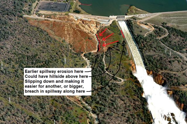
Well, it looks like the view the “sunlight reflection” of a couple days ago was really a breach in the sidewall of the main spillway. The main spillway is like a H with the main water flow groove, and a side wall on both sides to keep the water flowing down the central channel.
If I understand what I am seeing here, up above the original “hole,” back towards the spillway top, on the left side, you had a FAILURE of some of the concrete wall sections. This allowed the water to DIVERT from the main “channel, and shift left OUTSIDE THE CONCRETE CHANNEL, AND START ERODING, DIRECTLY ERODING THE DIRT THAT IS RIGHT NEXT TO THE SPILLWAY. The situation is you now have TWO SEPARATE DOWNSTREAM WATER FLOWS: THE FIRST ONE INSIDE THE SPILLWAY AND THE SECOND ONE EXITING THE WALL BREACH AND ERODING AWAY THE HILLSIDE, OR EVEN GOING BACK UNDER THE MAIN SPILLWAY AND CAUSING FURTHER DAMAGE TO THE CONCRETE SLABS ETC.
Yep, it is now a done deal in my opinion. The failure of the main spillway is now INEVITABLE. It will eventually fail, all the way from the sidewall breach, the one between/below the power lines, and the top of the spillway.
The erosion undercut going back up towards the spillway top, on the left side first, a day or so ago, and IT IS LIKELY CUTTING UNDER THE ENTIRE WIDTH OF THE MAIN SPILLWAY AND WILL LIKE CAUSE A SEPARATE BREACH ON THE RIGHT SIDE OF THE SPILLWAY WALL.
The whore media and politicians will spin this as best as they can, but we are going to see criminal charges out of this down the road. The failure to issue a mandatory evacuation order is an act of moral cowardice, cynical political opportunism and will destroy California for a generation. Nowski, amigo I am saying the state of Jefferson is going to be born out of this, since the hatred of the deplorables for that SCUMBAG GOVERNOR MOONBEAM HAS DONE TO THEM WILL HAVE NO LIMIT.
The main highway/freeway is I-5 and over it comes the tens of thousands of trucks that supply the “I-5 Corridor.” The rail lines are also linked to the I-5 corridor and carry every thing the entire coastal PNW, Portland, Seattle need.
You do have options, 101 Coastal Highway, 395 through Eastern Oregon, but they are not credible for mass truck transit.
In my opinion, the level of economic damage to the Agriculture Industry will be massive. It is not a case where you “can’t” get citrus fruit, or fresh vegetables, it will be a case of it will cost you more to import citrus from Florida, Texas or Arizona.
And I will say again to those of you who somehow think Governor Moonbeam is going to skate on this, especially if San Francisco Bay is full of floating corpses, it ain’t going to happen. The way the game works is the media and political whores get to do whatever they want until they screw up so bad people die. At that point, the larger system, the NWO , the globalists are quite willing to throw a mid level player like Governor Moonbeam to the howling wolves, if it will keep their butts out of the wolf pit.
Nope, Moonbeam is road kill because the real “they” the 300 families that rule the world, won’t hesitate to slit his throat to keep the mob happy. I live with Snowflakes, Nowski and when the Snowflakes lose one third, to one half of their drinking water, they are going to chop Moonbeam into tiny pieces.
Doomer Doug, a.k.a. Doug McIntosh now has a blog at www.doomerdoug.wordpress.comMy end of the world e book “Day of the Dogs” will soon be available for sale at smashwords. The url is
https://www.smashwords.com/books/view/267340 It is also at the following url
HERE ARE SOME LINKS TO CONSIDER.
https://radar.weather.gov/ridge/radar.php?rid=rgx&product=N0R&overlay=11101111&loop=no
Thanks to Shane from timebomb for the pic. THE GOOD NEWS ABOUT NUCLEAR DESTRUCTION!
WHAT TO DO IF A NUCLEAR DISASTER IS IMMINENT!
When An ill Wind Blows From Afar! (O
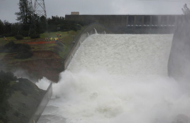
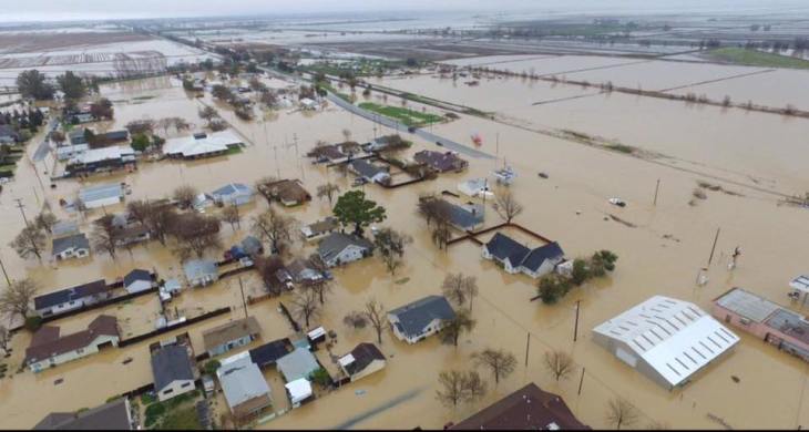
The above pictures show what I think, as well as Shane does, happened. The second picture shows the actual damage. The third picture shows flooding, as of 2-17-2017 at Maxwell, California downstream from the Oroville dam and spillway. We are already getting widespread reports of flooding downstream from both the Shasta Dam, which feeds into the Sacramento River, and the Oroville Spillway, which feeds into the Feather River.

![Get Out of California NOW [and North West Coast]](https://brutalproof.net/wp-content/themes/hueman/assets/front/img/thumb-medium-empty.png)